
Out of the Attic – London Air Raid Map

Veteran members of the Society will remember a time when transcriptions of family records – bible pages, newspaper articles, obituaries, funeral programs, commencement programs, and so on – were regularly found in the pages of our publications. We’d like to revive this practice and start featuring family records in our monthly eNews. We need your help to accomplish this.
Rummage around in your genealogical “attic” for unique family records. Then email us a transcription. Include an introductory paragraph to explain what the record is and where you found it. We’ll do the rest.
Send your records to newsletter@dallasgenealogy.org.
by Jo Ann Kelly-Graham
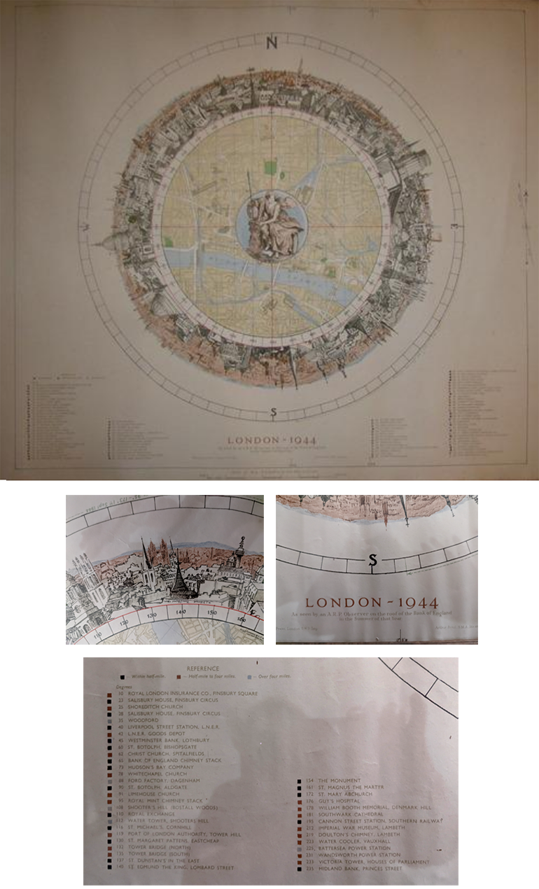
This map was given to my mother, Patricia Maureen (Jarrett) Kelly, as a result of her work in Civil Defense during World War II in England. The map was used by bomb spotters who stood on the roof of the Bank of England during German air raids of London. These spotters used the map to determine where bombs dropped and to send information to police and fire brigades so that they could fight the fires and rescue the injured.
My mother received the map in recognition of her volunteer work on the Rescue Squad while with the Bank of England in Overton. She worked for the Bank of England in London prior to the Blitz. Her department and many others of the Bank of England were evacuated to the countryside to protect the bank’s operations during the War. During the evacuation, which lasted years, women were stationed in Hurstbourne Park in Overton. Hurstbourne Park was the estate and manor house (castle) of one of the members of the Board of Directors of the Bank. The Bank officers were housed in the manor itself and the many female workers were housed in barracks built on the estate for the evacuation. This estate is located next to Highclere Castle which is the setting for the Downton Abbey TV show and movies.
Patricia remembered receiving this map from her boss after the war when the employees had been moved back to London from Overton. She said that there was no special ceremony. He just came to her desk and gave it to her.
Only 200 of these maps were printed by the Bank of England as a thank you to their employees who volunteered during the war. It was printed by Baynard Press in 1945. The original drawing by Arthur Bond, a member of staff of the Bank of England, was prepared for the use of observers on the roof of the Bank during air-raids. It shows a one-mile radius around the Bank. The circle is marked with degrees of the compass. The circle surrounding the map is a panorama of the surroundings as seen from the observers’ viewing position. The colored squares next to each building name indicates how far it is from the bank/center of the map.
- Description: 1 map : color ; 30 cm diam. on sheet 68 x 100 cm
- Cartographic Mathematical Data: Scale 1:10,560. 6 inches = 1 mile.
- Responsibility: Arthur Bond, S.M.A., inv. et del.
The Bank of England website says the following about the map: “Artist’s impression of a panorama view of the buildings surrounding the Bank of England which are shown encircling a reproduction of an Ordnance Survey map of the immediate area surrounding the Bank. The map, designed by Bank of England employee and artist Arthur Bond, assisted ARP (Air Raid Precaution) wardens during the period of the War when the Nazis were targeting London with the V-1 flying bomb. Two hundred copies were printed and these were given to members of bank staff who had served as firewatchers on the roof of the Bank (1944).”
Copyright ©2022 Jo Ann Kelly-Graham
Published by Dallas Genealogical Society with the author’s permission
