
Preparing for the 1950 Census
by Barbara A. Ware
The 1950 census will be released April 1, 2022. You can prepare for that event now. Many of the census enumeration maps are available through the National Archives and Records Administration (NARA) catalog as Record Group 29, Series Enumeration District and Related Maps 1880-1990.
Click on the “Search Within This Series” button. Enter a city and state or a county and state in the search box. Read down the list provided to select the map group you want to review. For example, searching for “Dallas, Texas” yields six groups of maps for 1950 Dallas County. This list is followed by Enumeration District map groups for 1940 census
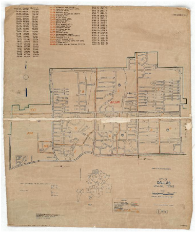
The first 1950 census group, “1950 Census Enumeration District Maps – Texas (TX) – Dallas – County – Dallas – ED 259-1 to 581” contains 16 maps which are easily reviewed. Each map has a key to where it is located among the other maps. Map image 1 has a list of various enumeration districts (ED) and the ED number that it follows.
Other information might be found on the ED maps. The one mentioned above contains a list of hotels, hospitals, academies with their ED number, plus block and tract location covering the whole set of maps. It also contains a legend to the drawing itself. So, it is a good idea to look at all the maps in a set.
Map 1 turned out to be interesting because it is a 1950 map containing a bare area where a new subdivision was created by the time my family moved there in 1951.
Click here to see a larger view of the map to the right.
In rural areas, maps may cover whole counties. For example, 1950 Collin County, Texas has two maps: all of Collin County and McKinney by itself. The Collin County map is a map that was prepared by the Texas State Highway Department and contains information on the location of houses, farms, factories, cemeteries and more plus the Enumeration Districts.
For more information see the NARA blog The Unwritten Record for the article “Census Enumeration District Maps for 1940 and 1950 Available Digitally in Our Catalog” by Amanda R. Pritchard.